Looking around southwestern Idaho’s desert ecology, you may not believe it, but one of the biggest floods in U.S. history took place right here. Starting in eastern Idaho, the prehistoric Bonneville Flood carved the current route of the Snake River, created Shoshone Falls, dropped gigantic boulders all along its route, and etched permanent changes in the Idaho landscape before making it out to sea.
Exactly when the Bonneville Flood happened is hard to pinpoint, but the best estimate is that it was 18,000 years ago, plus or minus a thousand years, said Dr. Jim O’Connor, a geologist with the U.S. Geological Survey, in Portland, Ore. It was caused when the giant prehistoric Lake Bonneville broke a natural dam and emptied out half its contents over what might have been just a few weeks.
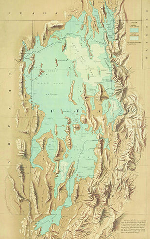
Historic Lake Bonneville. Map courtesy of Stephen S. Clark Library, University of Michigan Library.
And just how big was the Bonneville Flood? Estimates are in the range of 5,300 cubic-kilometers, or about the volume of Lake Michigan, O’Connor said. “Or for us Westerners, about seven times the volume of Puget Sound. Or 2 billion Olympic swimming pools,” he said. “A lot of water.”
The flood started at Red Rock Pass, near Downey, in southern Bannock County. “Toward the end of the last Ice Age, the climate was changing,” said Dr. Monte Wilson, a retired geology professor from Boise State University. The snowmelt and ice melt, along with the Bear River, flowed into Lake Bonneville, which kept rising. “The lowest place on the rim was Red Rock Pass, which is at the head of Marsh Creek, which runs into the Portneuf River, which runs into the Snake River,” he said. The pass, full of sediment, either burst or was overtopped and then began to erode rapidly, he said. “Around 350 feet of sediment eroded down to bedrock.”
The Flood’s Path
After that, the flood traveled down the existing canyons, which had been carved over the millions of years the Snake River had been running, Wilson said. How fast and how deep the flood was depended on the underlying geography.
“In narrow places, like in Twin Falls Canyon and Hells Canyon, it was on the order of 300 to 400 feet deep in places,” O’Connor said. “There are some places in Hells Canyon 600 feet deep.” And the narrower and deeper the canyon, the faster the water flowed. “Thirty to 40, maybe 50 feet per second (20-34 mph),” O’Connor said. “In the deep, narrow stretches, it was cooking along, which is why it could pick up boulders the size of small houses and SUVs.” In comparison, the Snake River typically flows today about one or two feet per second (approximately 1 mph), he said.
Where the canyon wasn’t deep enough to contain the flood, it overtopped the valley, ran over the surface of the ground, and stripped the sediment off the underlying basalt, making waterfalls, Wilson said. “Big blocks of basalt were ripped out of the canyon walls and floor and rolled and tumbled downstream.”
But what goes up must come down. “Obviously, if there’s erosion in one place, there’s deposition somewhere else,” Wilson said. Remnants of deposited sediment are visible around Hagerman and the Swan Falls area, he said.
Eventually, the flood went into the Columbia River, near Lewiston, and ultimately into the Pacific, Wilson said.
Did Anyone See It?
What’s not clear is whether anyone saw the event. There is no obvious evidence, such as tools or bones in flood deposits. And while floods are mentioned in Native American folklore, that’s not definitive, O’Connor said. “There are a lot of flood stories in Native American oral traditions, but there were a lot of floods, too,” he said. “There’s not enough detail to know that this flood story is from Bonneville and this one is from Channeled Scablands” in Eastern Washington.
The exact dates of both human habitation in Idaho and the flood are in flux, but at least so far, it appears that the flood happened before anyone was around to see it. “It’s not out of the question that there were people here,” O’Connor said. “The earliest known fossils are from 14,500 to 15,000 years ago, but that doesn’t mean people weren’t here before that. They could have been here earlier and no trace has been found. Every year, it looks like the timing of the first arrival gets pushed back.”
But even if there were people here at that time, their chances wouldn’t have been too good, Wilson said. “If there were early occupants here, they probably would have lived right along the river for water and fish, so the evidence of their habitation would have been wiped out by the flood,” he said.
Still, Wilson said he thinks about it sometimes. “It’s interesting to wonder what some early Native Americans would have thought, standing on the side, and the river started to come up so abruptly,” he mused.
6 Spots to See Traces of the Bonneville Flood
Red Rock Pass
Red Rock Pass is where The Great Flood broke through a natural dam 18,000 years ago. The amount of water equivalent to that in Lake Michigan raced across Southern Idaho creating what is today the Snake River. There are still remnants of the ancient borders of Lake Bonneville at Red Rock Pass. The current Great Salt Lake is shown in lighter blue.
Shoshone Falls
Shoshone Falls is among the most dramatic examples of erosion caused by the flood, Wilson said.
Dedication Point
The canyon walls of the Morley Nelson Snake River Birds of Prey National Conservation Area house the largest population of nesting raptors in the U.S. because the flood carved out great nesting places, Wilson said.
Swan Falls Dam
Just downstream, there are house-sized boulders ripped from the canyon where the dam is located and then dumped where the canyon widened and the flow slowed down, O’Connor said.
Celebration Park
Idaho’s only archeological park is full of “melon gravel,” or rocks, rounded by the current, that were dropped as the water slowed down. In some cases, Native Americans carved petroglyphs on the rocks.
Hells Canyon
Near Pittsburg Landing, you can drive into the canyon and “there’s a huge flood bar down there,” O’Connor said.
If you make it to Utah, you can always look at the last remnants of prehistoric Lake Bonneville. After the Ice Age ended and the climate changed, there wasn’t much snowmelt and Lake Bonneville basically evaporated down to the Great Salt Lake, Wilson said.