In the West, battles over water tend to get framed in terms of big abstract entities—municipalities, hydropower companies, agricultural conglomerates—wrestling over equally abstract terms: acre-feet, priority dates, and in-stream flows. However, underlying and informing all of those arguments, whether fought in the courtroom or, as in earlier days, with flesh and blood, is a fact much more visceral: Water is the most primal of substances on earth. A guy could live for weeks without food. Take away his water, and he’ll be dead in a few days.
Compared to other Western states, Idaho is relatively rich in water, consuming 19.5 billion gallons per day, the bulk of which, 80 to 85 percent, supplies agriculture. Only two states in the nation consume more: California and Texas.
Despite these apparent riches, water has always had devilish hold on the state. Beyond keeping people alive, water can transform landscapes. Add a little water to an arid place like Southern Idaho and plants and animals magically spring forth. Food grows, people come, communities thrive. An economic engine is jumpstarted. If one traces the economic and popular development of a Western state like Idaho, it soon becomes clear that water courses through the very center of it.
There is another simple but inescapable fact that is never very far from the debate about water, and that is its weight. For a given volume, water is remarkably heavy. Carry a six-gallon jug across a couple hundred yards of sagebrush and that reality becomes palpable. While gravity is a force with which we always reckon, rarely is the consideration as pressing as when trying to manipulate water for our needs. Where water flows and where we want it to be don’t always comport, and therein lies great cost and often great conflict.
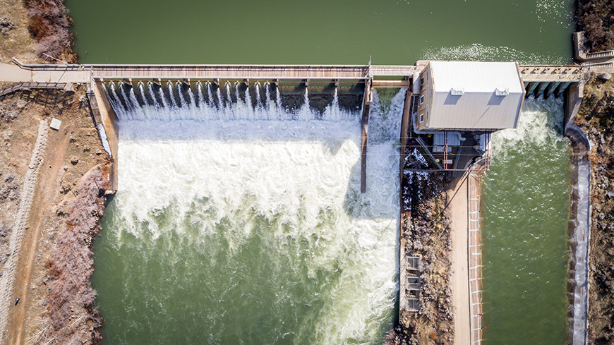
Boise River Diversion Dam, built in 1909, channels water into the New York Canal, which is a primary source of irrigation water for Ada and Canyon counties.
Certainly, gravity can be temporarily defied with technology; it’s just costly. Witness the Fryingpan-Arkansas project in Colorado, where water from the Fryingpan basin on the western slope of the Rockies is dammed in 16 places, channeled, and pumped 5.5 miles underneath the Continental Divide to the eastern slope of the Rockies and the thirsty residents of Denver. Depending on one’s perspective, that is either an engineering triumph or a fool’s errand.
Of course, water’s weighty nature isn’t all bad. It’s what makes it so effective at turning turbines, which generates relatively cheap electricity, which, in turn, enables businesses to grow and economies to flourish. So, for a simple little molecule, water is complicated.
The Accounting
Like everything else on earth, water is subject to the ultimate accounting system: the conservation of mass. It can’t be created or destroyed; it’s just moved around to different places and forms. This is a reality that sometimes gets lost in the debate.
Jim McNamara, chair of the department of geosciences at Boise State University (BSU), explained that the precipitation that falls on Idaho, generally in the form of snow, can really only go two places: into stream flows or into the soil. The former case is a simple fate; once in a stream, water follows gravity to the ocean. Alternatively, water moving down into the soil to what’s called the root zone can be sucked up by plants and trees. A small percentage of that water is used in photosynthesis (the process of converting carbon dioxide to sugars and oxygen), and the bulk, 98 percent, is transpired through the plants and trees and evaporates from the surface of leaves into the atmosphere. “These are losses out of the basin,” McNamara said.
Water that does not get transpired and instead moves down past the root zone will become part of a given aquifer, which McNamara described as being like a big underground sandbox. Water flows into cracks and pores, becoming, in effect, an underground water storage system (often referred to as groundwater). Ninety-two percent of Idahoans’ drinking water comes from groundwater.
Critical to understanding the water cycle and many of the water battles of recent history is the fact that aquifers are, in general, connected to river systems (surface water). Water is constantly flowing in and out of aquifers and back into rivers. As McNamara put it, major problems in modern water management have come about “… due to the lack of recognition that surface water and groundwater are the same water.”
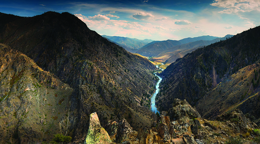
If one were to magically rise up into the sky and visualize the water flowing over and through Idaho—before the era of water management—the picture would be conceptually quite simple. Barring losses to evaporation and transpiration, the vast majority of the precipitation that lands on Idaho makes its way in to the Snake River via river and aquifer flows. Given Idaho’s complex topography and multitude of basins, water may flow east, west, north or south to get to the Snake, but it gets there. Gravity makes sure of it.
There are only two watersheds in Idaho that don’t feed the Snake: the Bear River drainage in the southeast corner of the state, and the very northern Panhandle drainages—basically the St. Joe River and those rivers north of it.
Prior Appropriation in a Lawless Land
Idahoans’ relationship to water, which ultimately became a legal one, really began in 1860 with Eli Pierce, a trapper who was convinced there was gold in the Clearwater River Basin. As it turned out, Pierce was right, and the Idaho gold rush was on. Miners streamed to the area.
As Paul Harrington points out in a 2012 Idaho Law Review article, “The lands mined at the time were part of the Washington Territory … There was no law enforcement, no courts, and no county organization … For all practical purposes, the early miners found that they had arrived in this country before the law.”
Remarkably, the miners soon established order on themselves. Peter Anderson, a Boise water attorney for Trout Unlimited, explained that the miners in this lawless land adopted practices established in the California Gold Rush. (In fact, several miners, including Pierce, had mined in California before venturing to what would become Idaho for more prospecting.)
In California, miners established mining districts with agreed upon rules for mining, the most important of which was that claims were based on first possession. Once a miner made a claim and continued to “work” it, that claim was protected from subsequent claims. With such claims, which were being made on public lands, miners weren’t vested with rights to the land, just to the gold in it.
“California miners, needing water [to run through sluice boxes in separating gold from sediment] simply applied old mining law ideas—the first in line concept—to water,” Anderson said. It is perhaps the most common strategy for allocating a limited resource, he explained. He likened it to a line for movie tickets. If the tickets run out, those at the back of the line are sent home.
This “first in time, first in right,” or prior appropriation doctrine, was grounded in mining law, but it was also adopted because it was uniquely suited to the dry climate of the West.
Anderson pointed out that in the East, basically east of the 100th meridian (which transects North Dakota and states on down), a farmer could grow crops on precipitation alone. Access to rivers wasn’t critical to the effort. Consequently, water law in the East was based on “riparian rights”: only those property owners adjoining a waterway were vested rights to the water. Water came with the land.
West of the 100th meridian, precipitation was such that successful farming required irrigation, which meant that water had to be pulled from the river. The same was true for mining; claims were often away from the river, so water had to be brought to the claims. Consequently, and contrary to the riparian system in the East, water rights in the West were from the beginning divorced from property rights.
“With the separation, land didn’t necessarily come with water,” Anderson said. “So, the state controlled the water in streams until you put it to use.” He said that the situation was analogous to hunting: the state owns the wild game on its lands until a hunter actually kills and takes possession of it.
While Idaho became a territory in 1863, it wasn’t until 1881 that the Territorial Legislature codified the prior appropriation doctrine into law. And when Idaho became a state in 1890, the doctrine became part of the Idaho Constitution, which stipulated, among other things, “The right to divert and appropriate the unappropriated waters of any natural stream to beneficial uses, shall never be denied. Priority of appropriation shall be give the better right as between those using the water …”
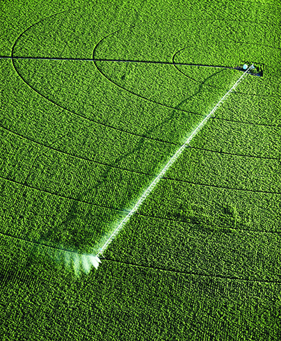
Turning a Desert Green. Today, there are approximately 3.4 million acres of irrigated land in Idaho.
The Era of Managed Water
While the gold and silver rushes of the 1860s and 1880s drew people to the Idaho Territory (there were 14,999 residents in 1870 and 88,548 residents when Idaho became a state in 1890), population growth might have petered out with the declining lodes of silver and gold but not for the advent of irrigation of the large swath of arid land that is southern Idaho.
Two acts of Congress, the Carey Act of 1894 and the National Reclamation Act of 1902 jumpstarted the transformation of what was basically a desert in southern Idaho. The former enabled and encouraged private companies to build irrigation systems that they could use to sell water. In addition, the new law established the General Land Office, precursor to the Bureau of Land Management, which transferred up to a million acres of federal land to each Western state to facilitate the building of such systems (several years later Idaho received another 2 million acres). The National Reclamation Act channeled money from the sales of semi-arid federal and territorial lands into the construction of irrigation projects.
It did not take long for such water projects to come online in Idaho. One of the first projects, however, was, a result of neither law, but rather a private hydroelectric power plant on the Snake River at Swan Falls. Todd Shallat, professor of history and urban studies at BSU, explained that the plant, which was built in 1901, was intended to support the use of electric trains to reach the mines in the Silver City area of the Owyhee Mountains. Shallat said that the grade to the silver mines was too steep for coal-powered trains. “However, by the time the dam and plant were finished, the silver mines had played out, so Idaho had lots of excess hydro then,” he added.
That the facility was built so early in Idaho’s history (1901), and therefore had a very senior water right, would later become an important fact in the pivotal 1980s Swan Falls controversy, which pitted irrigators against the electric company that owned the plant, Idaho Power.
As the new century unfolded, dams facilitated by the Carey and the Reclamation Acts began to pop up all over the Snake River Basin: In 1905 the Milner Dam was built just east of Twin Falls; the Minidoka and Jackson Dam rose in 1907; the Arrowrock and Lucky Peak Dam in 1915; the Henry’s Lake Dam in 1923; the American Falls Dam in 1927; the Island Park Dam in 1939; the Anderson Dam in 1950; and the Palisades Dam in 1957. The three dams in the Hells Canyon Complex went up from 1959 through 1967.
All of that damming correlated with a dramatic increase in irrigated acreage in Idaho. In 1890, there were approximately 217,000 acres of irrigated land. By 1930, the acreage had increased 10-fold to 2.2 million acres. Today, there are about 3.4 million acres of irrigated land in Idaho, which generates approximately $5.1 billion in revenue in a state economy of $59.7 billion.
Reaffirming State Sovereignty Over Water
Given the critical role water was playing in the economic development of the state, Idaho legislators recognized a need to actively manage this resource. In 1965, the Legislature, with Idaho Constitutional authority, established the Water Resources Board. It was charged with formulating and implementing a state water plan. Put simply, the state was reaffirming its sovereignty over the water in its streams and aquifers. In so doing, it aimed to quantify the supply and demand of water and to ensure that its use was in the interest of the public. For the most part, that meant shepherding economic development through the optimum “beneficial use” of water.
The Idaho Constitution specifies “beneficial uses” in general terms as those for domestic needs, agriculture, manufacturing, and mining. However, when the Water Resources Board was formed, the Idaho Legislature codified a somewhat expanded definition of beneficial uses when it committed to fostering “… minimum stream flow for aquatic life, recreation and aesthetics and the minimization of pollution and the preservation of waterways …”
This change was a recognition that how we define “beneficial uses” is subject to some evolution. What’s more, the term and how it is used in the Constitution seems to open the door to some subjective judgment. As water attorney Anderson pointed out, “Prior appropriation is built upon the idea of dynamic equilibrium—that you will have dry years and wet years … When issuing new water rights, we have to determine if water is available. It’s not really a beneficial use to start a farm with water available one out of 10 years … Would it be a beneficial use to raise rice in the Idaho desert?”
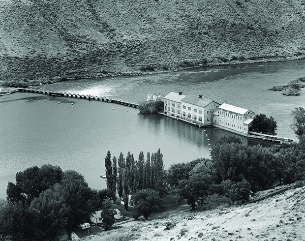
The SwanFalls controversy pitted Idaho Power, which had some of the state’s most senior rights, against 7,500 water users, primarily farmers upstream of the power facility. Photo: Historic American Engineering Record (Library of Congress)
A Watershed Moment at Swan Falls
If one considers the way water is used for irrigation versus the way it is used to generate electricity, it soon becomes obvious that there is an inherent tension between two major water users in Idaho. Irrigators pull water out of the river to put into the fields. While some of that returns to the aquifer and, ultimately, the river, much of it does not; it is lost to evaporation and transpiration. Hydroelectric power plant operators, on the other hand, want the water in the river. Higher flows mean more power generated and lower prices for consumers.
This tension approached a breaking point in the late 1970s and early 1980s when a group of Idaho Power Company ratepayers filed a complaint claiming the company had not fully protected its senior water rights (a 1901 priority) from those with junior rights upstream of the dam, which belonged primarily to irrigators. Had Idaho Power done so, ratepayers claimed, flows would be higher at Swan Falls and electricity rates would be lower.
A lawsuit ensued, and, ultimately, the Idaho Supreme Court ruled with the ratepayers. With ruling in hand, Idaho Power sued 7,500 water rights holders upstream of the dam demanding a curtailment of their junior water rights. In effect, Idaho Power had the legal right to shut off water to all 7,500 farmers upstream of them.
Given the potential economic wreckage such an action would create, the State entered into negotiations with Idaho Power to try to avert a disaster, as well as to avoid forever losing control of the major river coursing through its lands. Finally, in 1984, both parties came to an agreement that brought peace between the hydropower interests and those of the irrigators. Essentially, Idaho Power agreed to subordinate its senior water rights to all junior rights upstream at the time of the agreement with the provision that the state would maintain increased minimum flows in the river at the Murphy gauge just south of Boise. In addition, Idaho Power agreed to place any water rights for flows above the minimums into a “water trust,” administered by the state for future beneficial users upstream.
The settlement, while fiercely contentious, did avert the implosion of an agricultural sector. And given that Idaho Power’s business depended on economic development, a large majority of which was driven by agriculture at the time, the settlement likely saved it, too.
A Massive Reckoning – The SRBA
For nearly a century of its short history—first as a territory, then as a state—Idaho did not require water users to document nor even notify the state of their water use and, therefore, rights. One simply had to divert water from a source and put it to beneficial use. It wasn’t until 1963 that permits were required before appropriating groundwater and 1971 for appropriating surface water.
However, the Swan Falls settlement put into stark relief the need for the state to understand how much water in the Snake River Basin had already been appropriated. The state could not maintain minimum flows in the river (as they were required to do per the agreement) without knowing how much water had been spoken for and by whom over the course of the previous 125 years or so. There were also the issues of tribal water right claims, as well as federal claims that were spawned by the Wild and Scenic Rivers Act (1968) and the Endangered Species Act (1973). If Idaho was going to manage its water, these all had to be quantified.
Adjudicating all of the water rights in the Snake River Basin was a monumental task that spanned 27 years and cost over $27 million. Over 158,600 individual water rights were decreed, which the late Supreme Court Justice Antonin Scalia said amounted to “one decree every 90 minutes, an astonishing pace by anyone’s standard.”
Finalized in 2014, the Snake River Basin Adjudication (SRBA) superseded all prior rights decrees and provided an agreed upon baseline of all water rights for planning potential future appropriations. The SRBA also enabled conjunctive management, the ability to look at entire streams and parse the rights and flows of both surface and groundwater. It was an official recognition that the two water sources were interconnected and, as such, had to be managed “conjunctively.”
Prior Appropriation Softens a Bit
Since the early 1950s, when wide scale ground pumping began in southern Idaho, the level of the Snake River Aquifer as measured by flows at Thousand Springs has declined dramatically. The amount of water in the aquifer has decreased by 13 million acre-feet (4.2 trillion gallons) in the last 63 years. The more water pumped from the aquifer will, in general, leave less available in the river for surface water rights holders, most of whom have rights senior to the groundwater users.
In some years there is plenty of water to go around, so all rights holders get their allocations. But in times of drought, like the spring of 2015, “The doctrine of prior appropriation can be harsh,” explained Mark Davidson, director of conservation services at The Nature Conservancy. That spring, surface water users, who had senior rights, were in a position to make a water call of 90,000 acre-feet on those with junior rights, predominantly groundwater users. In effect, the call would turn off water to those junior users, which included farmers working 157,000 acres, 500 dairies, and 14 cities. The potential economic damage was in the millions of dollars.
Rather than litigate in court, the surface and ground water coalitions negotiated an agreement whereby ground water users would reduce their annual use by 13 percent—whether through improved efficiency, shortening their irrigation season, or fallowing land—and the surface water users would not make water calls on the groundwater users. There were also agreed upon efforts to install flow meters on pumps and for the state and groundwater users to recharge the aquifer each year in order to get it back to levels seen between 1991 and 2001. In sum, it marked a new era of cooperation among users in a watershed.
“To me, the interesting thing that is happening in Idaho is that water users are actually trying to find ways to come together and resolve these kinds of problems, like they did on the Snake River Plain [in 2015],” said Davidson. “The Teton Basin has a similar thing going on, and the Big Lost … people are trying to figure out, ‘how do we work together as a watershed to solve our own problems.’ … that is really the new shift we are seeing in Idaho.”
Democracy and Conservation
Speaking at a recent Andrus Center conference on Idaho’s water at BSU, Patty Limerick, director of the Center for the American West at the University of Colorado, discussed what she referred to as the American experiment with conservation.
“The practices we know as conservation originated in centralized regimes of power. Kings, aristocrats, and colonial governors began what we now consider practices of conservation.” She was referring to kings ruling over large estates of land and maintaining the land to their preferences, particularly in relation to hunting and locals poaching game.
“So that makes the American experiment with conservation … [shifting out of a framework of a centralized authority]… globally important because the experiment we’ve been engaged in for the last 140 years since the start of federal land management, public land ownership, and reclamation … is testing the compatibility between democracy and conservation.
“Every day in a water managers life is an important data point in that experiment. How does that work? To be surrounded by constituents, individuals, and citizens, all wanting something from you as you navigate through this conundrum of how you take practices that are much easier to implement from a top-down, centralized authority—how do you make that work in a democratic republic?
“In those terms, there are reasons to feel we are watching something like progress… We were talking about litigation, and, I thought, ‘from a Western historian’s perspective, I’ll take it.’ Showing up in courtrooms as opposed to showing up on battlefields? … That’s a form of progress. That so many of our primal struggles for dominance, for resources, for the allocation of goods we want, we go to the courtroom rather than to Main Street, or to the battlefield. I’ll take that. And if we are now seeing some sort of evolution to a follow up stage of collaboration, cooperation and negotiation, if that doesn’t count under the term progress, I don’t know what does.”