Idaho, like so many of the Western states, is a place with dueling narratives. One is the elegantly simple story of the land, the other a maddeningly complex story of land use.
The first spans the millions of years before nations and governments came along; the second plays out over the most recent few hundred years when Europeans and the nascent Americans brought to a wild America the concept of land ownership.
Purists with a long view of the world would argue that no one can truly own the land. Nonetheless, the way in which land is owned and designated, whether in the broadest terms as a collective public domain or as a private commodity, has a profound effect on our relationship to the land and how we use it. The West looks the way it looks—with its vast stretches of open land—not because it was wilder or less tamable than the East. It was literally man-made; the politics of the West’s land acquisition and ultimate disposal sealed its fate.
Three Broad Strokes
Given its size, Idaho is a place is hard to fathom from the ground. However, take to the air over the state and the seemingly endless majesty of the place unfolds in every direction. The geography appears uncommonly simple: three broad strokes of geological wonder. First, a great swath of the Rocky Mountains runs north from the bulky center of the state on up into Canada. Second, as if cradling the Northern Rockies, the massive Snake River Plain, created by a series of basalt (lava) floods of the Yellowstone hot spot, stretches its wide smile across the full width of the state. Finally, basin and range regions run across the southern and southeastern regions of the state. The Lemhi and Big Lost Ranges, which drain into wide fertile valleys, are typical of this area.
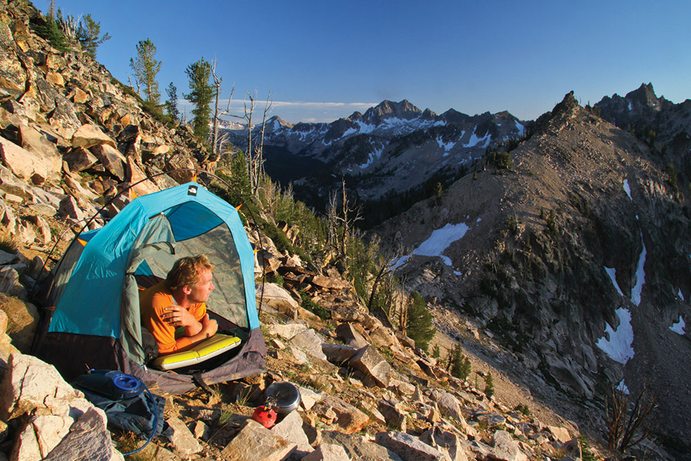
Photographer Matt Leidecker, camped above Baron Lakes in the Sawtooth Mountains, scopes out a potential high alpine sunrise shot.
Of course, the specific geology of how this enormous tableau was assembled is far from simple. Nonetheless, the appeal to the soul of such grand strokes of the natural world could not be more basic. What Idahoan wouldn’t be proud of such a place?
The irony is that, according to the Congressional Research Service, most of Idaho does not belong to Idaho. Nearly 62% of the land within its borders belongs to the federal government. Other Western states—Alaska, Nevada, Utah and Oregon—have similar or even higher federal ownership.
How did Idaho become a minority stakeholder in its own state? It is a direct result of decisions, specifically acts of Congress and international treaties, made in the formative years of the nation.
Assembling a Nation
From the time the Revolutionary War ended with the Treaty of Paris in 1783, through the purchase of Alaska in 1867—fewer than 85 years—the U.S. increased its land domain by five fold, adding 1.84 billion acres. That’s the equivalent of adding about 35 Idaho’s to the nation.
The dizzying expansion began with the 13 original states ceding to the new federal government title to all of the lands between the Appalachian Mountains and the Mississippi River. With the Louisiana Purchase from France in 1803, the U.S. added 530 million acres. Soon to follow were the additions of the Florida lands in 1819; the annexation of Texas in 1845, the Oregon Country cession from Great Britain in 1846, which included all of the land from the Rocky Mountains to the Pacific Ocean between the 42 and 49th parallel (Idaho’s southern and northern boundaries, respectively), and the Mexican cession of 1848, which included California, Nevada, Utah, Arizona, and parts of Wyoming, Colorado and New Mexico. When the U.S. purchased Alaska from Russia in 1867, a final 378 million acres were added to federal lands.
The Great Giveaway
Almost as fast as it was acquiring vast stretches of the West, the U.S. government was disposing of lands through the General Land Office, precursor to the Bureau of Land Management.
Largely because it had significant debts after the Revolutionary War, the U.S. government began selling and transferring lands—ultimately 816 million acres—to private landowners through the Homestead Act and to the private railroad companies. The hope was to settle the West and reap the rewards to follow.
The Middle Fork of the Salmon is a wild and scenic river within Idaho’s Frank Church River of No Return Wilderness, which spans more than 2.3 millions acres.
The federal government gave away another 471 million acres to new states, including provisions for schools in every township of every new state. Upon becoming a state in 1890, Idaho, for instance, was endowed with 3.6 million acres of land to support state institutions, including public schools, the University of Idaho, state hospitals for the mentally ill, Lewis-Clark State College, Idaho State University, state veterans’ homes, the Capitol Commission, Idaho School for the Deaf and Blind, and the juvenile corrections system and prison system. Any income generated by these lands, for example, revenue from land leases on McCall’s Payette Lake, goes into the Idaho Department of Land’s endowment fund and is then distributed to these beneficiaries.
In all, 1.29 billion acres were disposed of in a flurry of 19th century largesse.
A Change of Federal Heart
If there was one event that changed the course of federal land policy from disposal to retention, it was the exploration of lands that what would eventually become Yellowstone Park. While Native Americans had been in the area hundreds of years earlier, it was an expedition in 1871 by geologist Ferdinand Hayden that was pivotal in paving the political path to park status. Hayden brought along photographer William Jackson and painter Thomas Moran to document the trip, which enabled members of Congress to see through art the wonders of Yellowstone. Even with the seemingly boundless resources of the West, Congress recognized the value in preserving land for later generations. In 1872, the U.S. Congress, with the signature of Ulysses S. Grant, created Yellowstone National Park, the world’s first national park and one “dedicated and set aside … for the benefit and enjoyment of the people.”
Land Management Era
Once Yellowstone changed the tide of federal land policy, the U.S. government began to actively manage the properties it owned. For example, in an effort to protect federal timber and long-term sustainability of the timber industry, the Congress passed the Forest Reserve Act of 1891. The law gave the president the ability to create forest reserves—later renamed national forests—from public domain lands. According to the U.S. Forest Service (USFS), which administers these lands, national forests now comprise 193 million acres nationwide, 20 million of which are in Idaho. The Forest Service’s management goals for these lands include maintaining recreation opportunities, livestock grazing and preserving wildlife and fish habitats.
As the number of national parks and monuments increased dramatically through the turn of the century and the presidency of Theodore Roosevelt, in particular, Congress created in 1916 the National Park Service (NPS) to manage and preserve natural, historical and cultural resources in the park system. These resources today include national monuments such as Idaho’s Craters of the Moon; national reserves like City of Rocks; and national recreation areas, such as the Sawtooth National Recreation Area. The Park Service is challenged with balancing preservation of the resources with providing public access and enjoyment of them.
The federal agency that administers more federal land than any other is the Bureau of Land Management (BLM)—originally the General Land Office. It manages 248 million acres nationwide and 12 million acres in Idaho. The BLM’s management mission is similar to the USFS in that it is trying to maximize return on multiple uses, including recreation, livestock grazing, timber harvesting, and wildlife habitat.
Unlike the BLM and USFS, which must balance multiple uses within their lands, the Fish and Wildlife Service (FWS) has a primary-use mission, that is, to conserve plants and animals. Some consumptive uses, such as mining, timber harvesting and even hunting, are permitted but only if they do not threaten the needs of wildlife. Nationwide, the FWS administers 89 million acres, most of which is in Alaska. Within Idaho, the FWS oversees seven refuges: Kootenai, Deer Flat, Camas, Minidoka, Grays Lake, Oxford’s Slough, and Bear Lake.
One of the last pieces in the federal lands puzzle is the Department of Defense, which manages 19 million acres nationally—a little over 4,000 acres in Idaho—for use as bases and training areas. The Department of Energy also maintains lands, primarily for their national labs, such as the Idaho National Lab, which spans 570,000 acres in Idaho.
And, finally, according to data compiled by Abelardo Rodriguez of the University of Idaho, Native American lands in Idaho comprise 1.9 million acres across five reservations. While not federal land, the Native American territories represent approximately 4% of Idaho’s land area.
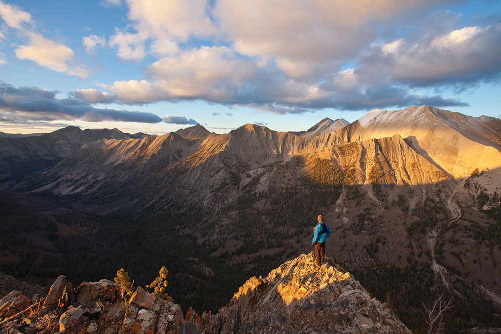
Strawberry Point above Warm Spring Creek provides a stunning panorama in the White Cloud Mountains
Key Conservation Legislation
On top of this framework of federal land protection, the Congress in the 1960s and early 70s added four pieces of legislation that have had a profound effect on land use and conservation. These were the Wilderness Act of 1964, the Wild and Scenic Rivers Act of 1968, the Endangered Species Act of 1973, and the Federal Land Policy and Management Act of 1976. Senator Frank Church of Idaho sponsored the first two of these bills.
The Wilderness Act not only defined wilderness for the first time, but it also imposed certain prohibitions on land deemed to be wilderness. In the words of Howard Zahniser, once executive director of The Wilderness Society and author of the bill: “A wilderness … is hereby recognized as an area where the earth and its community of life are untrammeled by man, where man himself is a visitor who does not remain.”
To ensure that the land would be “untrammeled by man,” Congress prohibited commercial enterprises, structures, permanent roads, and motorized vehicles—even mechanized transport such as the use of a bicycle was prohibited. Just as national park designation was more stringent than that of a national forest, wilderness area designation was more protective still.
The act has had a significant effect on Idaho, as nearly 4.52 million acres of federal land within the state has been designated as wilderness. Only Alaska and California have more wilderness acreage. Perhaps the most notable such area in Idaho is the Frank Church River of No Return Wilderness, which encompasses 2.3 million acres in the center of the state. Of the 12 wilderness areas in Idaho, some of the more prominent are the Craters of the Moon, Sawtooth, Gospel-Hump, Selway-Bitteroot, and Hells Canyon Wilderness Areas.
The Wild and Scenic Rivers Act of 1968 sought to achieve similar protections for rivers, stipulating that rivers so designated would remain “free-flowing” and protected for future generations. The law goes on to further designate “wild,” “scenic,” and “recreational” river stretches with corresponding restrictions on use. Idaho boasts 891 miles of wild and scenic stretches, including parts of the Main and Middle Fork of the Salmon, sections of the Bruneau and Clearwater Rivers, as well as a stretch of the Snake River below Hells Canyon Dam.
The third major piece of legislation shaping land use in the West and Idaho in particular is the Endangered Species Act of 1973. Designed to stop and reverse species extinction caused by human development, the law protects not only endangered species, but also the habitats on which they depend. It is the latter stipulation that has been the grist for many protracted legal battles. Politics aside, the law has worked as intended in that it has brought many species back from the edge of extinction. Some of the animals saved to date include bald eagles, grizzly bears, California sea otters, and peregrine falcons.
Finally, if there is a point at which the massive disposition of federal lands formally ended and, therefore, previously conserved lands were locked in place, it was the passage of the Federal Land Policy and Management Act (FLPMA) of 1976. Not only did the law repeal the Homestead Act, federal land sales and transfers, but it also asserted that the “public lands be retained in Federal ownership unless … it is determined that disposal of a particular parcel will serve the national interest.”
All That Endures
When the bill to establish Yellowstone Park was debated, Senator Cornelius Cole of California, an outspoken opponent of the legislation, said on the Senate floor, “The natural curiosities there (Yellowstone) cannot be interfered with by anything that man can do.”
He may have had a point in 1872, but today there seems to be little limit to our capabilities or to the impact private ownership has on land use. However, perhaps the larger point to consider is not what man can do to the “natural curiosities,” but what the “natural curiosities” can do to man.
With the creation of Yellowstone, pristine land was for the first time in the history of our nation deemed to have inherent value. There was recognition that an aesthetic experience in the natural world might save a soul as readily as would a timber job. What was then just an inkling of an idea is now part of our cultural values: that when people go out into great wild places something transformative can happen. A connection is established to a bigger, natural world that will likely endure forever. At least, that is the hope.